Best Boating Weather Apps for Safe Marine Forecasts 2026

What are the best boating weather apps for U.S. marine forecasts?
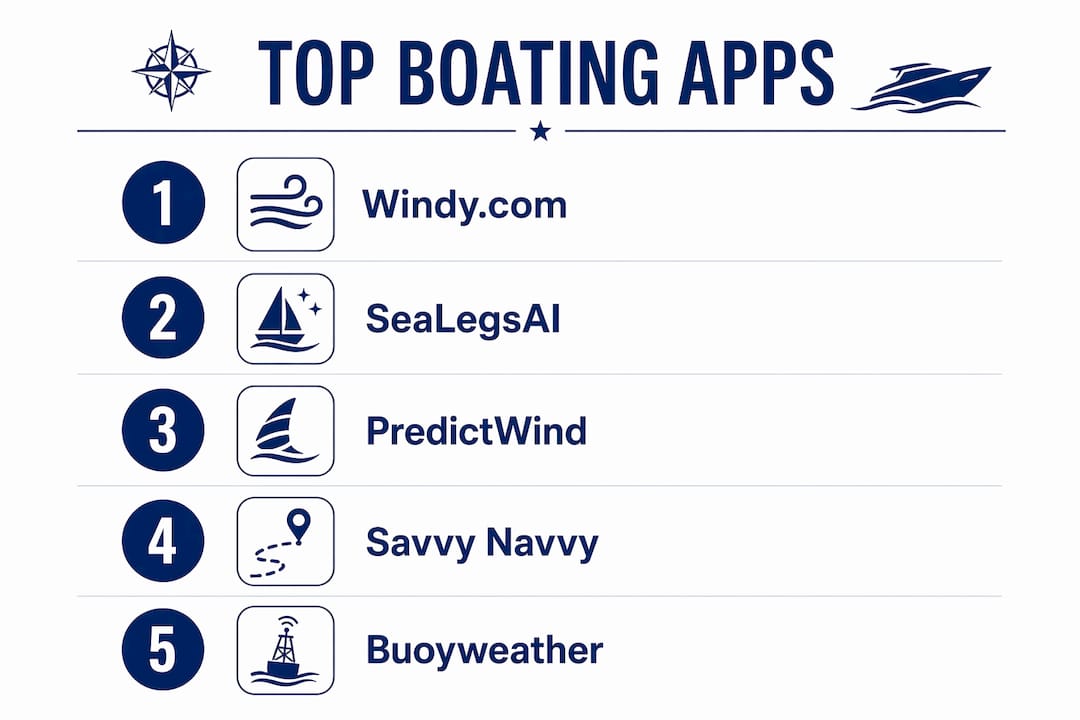
The strongest options for U.S. recreational boaters right now are SeaLegsAI, Windy.com, NOAA Marine Weather Forecast, PredictWind, and Savvy Navvy Ltd. Each one serves a different kind of boater, and picking the wrong one means either drowning in raw data you can’t act on or getting oversimplified guidance that misses local conditions.
SeaLegsAI analyzes 12+ weather models using AI and delivers a plain Go, Caution, or Avoid recommendation for your specific route. Free tier available on iOS and Android.
Windy.com offers over 40 map layers with animated wind and wave visualization. Free, with an optional low-cost Premium plan.
NOAA Marine Weather Forecast provides official U.S. National Weather Service zone forecasts at no cost. The authoritative baseline every other app builds on.
PredictWind delivers professional offshore weather routing, GRIB file downloads, and departure planning tools for sailors and passage planners. Plans run $29–$499/yr.
Savvy Navvy Ltd. combines charts, tides, AIS vessel data, and weather overlays in one app. Winner of the Boating Industry Awards Top Products 2025, with plans from $99–$189/yr.
Buoyweather focuses on offshore fishing with point-based forecasts and a 16-day forecast range, plus real-time buoy observations.
FishWeather targets inshore and nearshore anglers with a large network of weather stations and fishing-specific predictions. Plans run $45–$180/yr.
BoatUS pairs marine weather and tide charts with boating safety resources for casual U.S. boaters.
Wavve Boating gives boat captains a user-friendly daily marine weather interface popular among U.S. boating communities.
How do the best boating weather apps compare on accuracy, features, and price?
Forecast accuracy depends less on which single app you pick and more on how many models that app draws from. Comparing multiple models like ECMWF and GFS is the standard professional meteorologists use, because localized microclimates along U.S. coasts can cause real discrepancies between models.
App | Forecast Accuracy | Key Features | Ease of Use | Pricing | Best For | Rating |
SeaLegsAI | 12+ models, AI-analyzed | Go/Caution/Avoid, route-based | Very easy | Free tier available | Recreational boaters wanting clear guidance | — |
Windy.com | 40+ model layers | Animated maps, radar, satellite | Moderate | Free; Premium $20/yr | Visual weather exploration | — |
Proprietary + ECMWF, GFS, ICON | Weather routing, GRIB, departure planning | Advanced | $29–$499/yr | Offshore sailors, passage planners | — | |
Multi-model | Charts, AIS, tides, weather overlay | Easy | $99–$189/yr | All-in-one navigation and weather | 3.8★ (23 reviews) | |
Buoyweather | Buoy-referenced, point-based | 16-day range, wave and swell data | Moderate | Free; Pro ~$96/yr | Offshore fishing | — |
FishWeather | Weather station network | Nearcast AI, fishing-focused | Easy | $45–$180/yr | Inshore and nearshore anglers | — |
NOAA Marine Weather Forecast | Official NWS zone forecasts | Wind, waves, tides, marine warnings | Easy | Free | Free official U.S. forecasts | — |
BoatUS | NWS-based | Tide charts, safety resources | Very easy | Free | Casual recreational boaters | — |
Wavve Boating | Standard marine models | Daily forecast, boating community | Very easy | Free tier available | Everyday boat captains | — |
Pro Tip: Most experienced boaters run two apps side by side: Windy.com for the full weather picture and SeaLegsAI for a clear decision on whether to go. Together they cover both the data and the judgment call.
The testing methodology behind the top-ranked comparisons for 2026 evaluated apps on forecast sources, feature depth, ease of use, and pricing across ten popular marine weather tools. Apps that aggregate more models and translate that data into actionable guidance consistently outperformed single-model apps in real-world coastal conditions.
How do you choose the best boating weather app for your needs?
The right app depends on three things: how you boat, how much data you can interpret, and whether you need it to work offline.
Match the app to your boating style:
Casual day boaters on familiar water do well with NOAA Marine Weather Forecast or BoatUS. Both are free, straightforward, and cover the basics without requiring any weather expertise.
Offshore fishermen should look at Buoyweather for its buoy-referenced point forecasts and 16-day range, or FishWeather for its station-dense, fishing-specific predictions.
Sailors planning multi-day passages need PredictWind. Its weather routing for powerboats and sailboats calculates optimal departure windows and routes based on your vessel’s specific dimensions.
Recreational boaters who want a simple answer rather than raw data should start with SeaLegsAI. It removes the guesswork entirely.
Key features to evaluate before downloading:
Multiple model support (at minimum, GFS and ECMWF)
Marine-specific data: wave height, swell period, swell direction, tidal currents
Hourly breakdowns, not just daily summaries
Offline access for areas with poor cell coverage
Route-based forecasting rather than single-point data
Pro Tip: Check real-time buoy data near your route before departure. Models can lag local conditions by several hours, and a nearby buoy reading often tells you what’s actually happening right now.
Offline capability matters more than most boaters realize until they’re two miles offshore with no signal. PredictWind and Savvy Navvy both support GRIB file downloads for offline use.
Detailed reviews of the best boating weather apps
SeaLegsAI takes a fundamentally different approach from every other app on this list. Rather than presenting raw forecast data, it analyzes 12+ weather models and evaluates conditions along your planned route, not just at a single point. The result is a plain-language Go, Caution, or Avoid recommendation. For recreational boaters who don’t want to become amateur meteorologists, that’s exactly the right design.
Windy.com is the visualization standard. Its animated wind and wave maps, over 40 model layers, and side-by-side model comparison make it the tool experienced boaters use to understand the full weather picture. It’s free, which makes it a no-brainer addition to any boater’s phone.

PredictWind sits in a different category from the rest. Its weather routing calculates optimal routes based on your vessel’s polar data, accounting for wind, waves, and currents. The departure planning tool summarizes what conditions you’d encounter leaving on day 1, 2, 3, or 4, letting you pick the best window. Plans start with a basic subscription and scale up for full offshore capability.
Savvy Navvy Ltd. earned the Boating Industry Awards Top Products 2025 recognition for good reason. It functions like Google Maps for boats, calculating routes that account for weather, tides, and hazards simultaneously. The AIS overlay adds real-time vessel awareness, which matters in busy coastal waters.
Buoyweather has served the offshore fishing community for over two decades. Its point-based forecasts reference actual buoy observations, and the 16-day range gives offshore fishermen the planning horizon they need. The free tier covers basic access; the Pro plan runs approximately $96/yr.
FishWeather is purpose-built for anglers. Its large network of weather stations and Nearcast AI predictions focus specifically on fishing conditions rather than general marine weather. Plans vary with different feature access options for anglers.
NOAA Marine Weather Forecast is the foundation. Every other app on this list pulls from NOAA data at some level. Going straight to the source gives you official zone forecasts, marine warnings, and small-craft advisories at no cost. The tradeoff is that you interpret the data yourself.
BoatUS and Wavve Boating both serve casual boaters well. BoatUS pairs weather with boating safety resources, making it useful for newer boaters who want context alongside forecasts. Wavve Boating’s clean interface is popular among U.S. boat captains who want reliable daily updates without complexity.
How do professional captains use marine weather apps safely?
Private captains and licensed guides don’t rely on a single app or a single model. The standard practice is to cross-reference at least two sources before departure, then verify against real-time buoy data near the planned route.
Weather routing and departure planning tools, once reserved for offshore sailing, are increasingly valuable for recreational powerboaters managing small groups and family comfort. Checking conditions along the full route, not just at the launch point, is what separates a good trip from a cut-short one.
Route-based forecasting is the key distinction. A point forecast tells you what the weather looks like at the marina. A route-based forecast tells you what you’ll encounter at Shell Island, three miles out, an hour from now. For private tours and family outings, that difference determines whether guests have a great experience or spend the ride back soaked and uncomfortable.
Key Takeaways
The best marine weather apps combine multi-model accuracy with clear, actionable guidance, and no single app does everything perfectly for every boater.
Point | Details |
Use two apps, not one | Pair Windy.com for visualization with SeaLegsAI for clear Go/Caution/Avoid decisions. |
Model count matters | Apps drawing from GFS and ECMWF together deliver more reliable coastal forecasts than single-model tools. |
Route-based beats point-based | Forecasts along your full route catch conditions your marina reading will miss. |
Offline access is critical | PredictWind and Savvy Navvy support GRIB downloads for areas with no cell coverage. |
Pcbprestige uses this approach | Pcbprestige’s licensed captains in Panama City Beach cross-reference marine weather data before every private dolphin and snorkeling tour. |
The marine weather app landscape is changing faster than most boaters realize
The conventional wisdom has always been: learn to read a NOAA zone forecast and you’re set. That was reasonable advice for a long time. NOAA’s data is authoritative, free, and covers every U.S. coastal zone. But zone forecasts were designed for professional mariners who can interpret “wind NE 15–20 knots, seas 3–5 feet” and immediately know what that means for their specific vessel on their specific route.
Most recreational boaters can’t do that translation reliably, and they shouldn’t have to. The real shift happening in 2026 is that AI-powered apps like SeaLegsAI are doing that translation automatically, pulling from more models than any individual could monitor and delivering a verdict rather than a data dump. That’s not dumbing down marine weather. It’s applying the same multi-model comparison methodology professional meteorologists use, just faster and at scale.
What I’d push back on is the assumption that more data always means better decisions. Windy.com’s 40+ model layers are genuinely powerful in the hands of someone who knows what ECMWF versus GFS divergence means for a Gulf Coast afternoon. For everyone else, that same interface can create false confidence. Knowing which tool matches your actual skill level is the real selection criterion, not which app has the most features.
Private tours on the water deserve the same weather rigor as offshore passages
If you’ve spent time comparing marine weather apps and want to experience what it looks like when a licensed captain applies all of this in practice, Pcbprestige’s private dolphin and snorkeling tours in Panama City Beach are worth a look. Every trip runs on a 26-foot powerboat with a licensed local captain who checks conditions before departure, not after guests are already aboard.
Unlike crowded group tours that run on fixed schedules regardless of conditions, Pcbprestige operates private charters with flexible itineraries, which means weather-driven adjustments happen before you leave the dock. Families, couples, and small groups get Shell Island, dolphin watching, and snorkeling in calm, safe water, with all equipment included. Book your private tour and let the captain handle the forecast.
Recommended
Comments